May 6, 2011

River Watch 2011, Island Life

Today brings another day in our Flood 2011. 


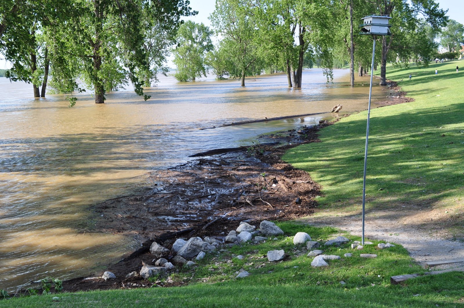
This photo is from the north end of the island. Can you see the light post in this photo?


There are a few light posts in this photo. This is actually a very large parking lot. If you look closely, you can see the light post in the center of the photo. Notice how far out it is. That's how big the parking lot is.


You should not see ANY water in this photo.


This is our bird house. It's the bird house that I have been using as my marker in all my previous post. I felt sad when we rode our bikes today and found it sideways.


This is a photo of where I've been standing to take all the photos in the previous posts. I've stood with my back to the bike rack and shot to the side of the metal hoops. 


Today, the city began building up part of the main road onto the island. We only have one way in and out of the island now, and part of that road is lower than the elevation that the river will crest at on Wednesday. So, they have been building up that section of the road to keep the river out. They've been working on the roads today, and cut the roundabout down to two lanes. Crazy traffic.


This is a photo of the sand/dirt elevation they are adding to the road.


This is the crazy traffic.


And, the dirt/sand. We're not sure if they will let us drive on this dirt elevation, or if they will continue to divert traffic to one lane each way.


This dirt elevation covers the right lane of the out-going lane.


Here's the thing: I love our island.


We're still safe, and I want to be sure we stay that way.


We are fine, and we appreciate all of your concern. We are so happy to see the Memphis Police Department patrolling the island, the city of Memphis building up our roads and our neighbors offering to help one another.


Life on the island isn't so bad. We're on guard and doing our due diligence to stay on top of all the information. A few of our neighbors have left for a few days and a few have had sand delivered to their yards to make sand bags, but we're okay. 

The view is nice.


May 5, 2011

River Watch 2011, no parking

So here's our latest report. These photos were taken on Wednesday. 

This photo is taken looking toward the place I've been taking all the other photos. Do you see the very small man? He's standing where I have been standing. 


This photo is in comparison 


to these two photo. Where that lady and other people are standing is under water. 


This photo is where I parked my car


 on Tuesday. This photo was taken when I was standing at my front door. So the perspective is different but the location is the same. The above photo shows where my car was, and this below photo shows the view from my car. Make sense?


This is the Wednesday photo from the same spot I've been using. Same bird house, same far-right marker tree on the right. Yeah, the water is much past the tree line. 


 These next photos are another look at where I parked on Tuesday, just to show the waves that are coming in. Those waves could end up being be more dangerous than the actual river level. 


Here's one of our beautiful trees, which you should be able to see the entire trunk...and another 35 feet to the left. 


Last weekend, Chris worked on our good flood Karma and helped make sandbags for the city. Here he is with his work people. He's in the light blue shirt. 


 We're still okay, but I do think "the flood of 2011" will become a story we annoy our children with. 

Need a new book to read?

My second book review for the BlogHer book club is up! We read Girl in Translation by Jean Kwok. Head on over to my review to see what I thought about it. You'll see I even received a comment from the author herself!

May 2, 2011

River Watch 2011, precautions

This is the level of the river on Sunday. 


Scroll down to the earlier post to see the original river levels. See how far the water has come past the furthest right tree?


People have been coming from all over to see the river. The traffic on the island has been crazy due to all of the "gawkers."


This is the last photo from Sunday from this spot. You can see where the water was already piling up in the middle of the lot.


I can't show you today's level because they have closed off the parking lot from which I took this photo. They've closed it off because the water is soon to flood the parking lot. 

They are now predicting a river crest of 48 feet. Previously they predicted 45 feet. This would still keep our house in the clear; however, parts of our island will be flooded. It may be that some of our roads are flooded. We're looking at the possibility of being stuck in the house for a few days. 

As of right now, our preference is to be stuck in our house on the island rather than leaving it. We hope we won't have to make this decision. We've had tons of wonderful friends offer their homes, and we may have to take someone up on their offer, but we hope not to. 

I made the run to Target and Whole Foods today to get flashlights, batteries and food. I also got a tiny collar for Porter and a custom tag. This sounds strange, but in the crazy chance that we have to leave the house (Porter has a carrier, which he will be in), but we also wanted him to have a collar. Isn't it weird the things you think of when you're faced with a slight emergency situation? Grace has a collar with her information, so she will be identifiable too. 

We hope that all of these precautions are not needed, but you don't ever want to look back and wish you had done something differently. 

So that's where we are. We're fine. We've made plans, and we're hoping that this flood doesn't impact us or anyone. We can deal with a few flooded roads and some inconvenience. We know people all over the mid-south have experienced terrible tragedies because of storms, and we plan to just hold the fort down on our little island!

That's the muddy truth!


April 28, 2011

River Watch 2011

Thank you to everyone who has called, emailed and texted in regards to the ever-increasing level of the Mississippi River. 

Living downtown in Harbor Town, we are very close to the river, and so we are on watch. 

This is the river today. Depth is difficult to understand in these photos, but keep your eye on the line of trees furthest to the right in this photo. Can you see that the water and debris line is past it? 


I think I've made up the word "debris line," but it is so fitting with this flood because the huge amount of water is carrying large pieces of debris, such as this entire tree.


Here's another look from the same spot as the first photo. See the debris line past the furthest right tree?


This is still today, and this is further down the park, away from the I40 bridge and closer to where the Wolf River empties into the river.


Between the grass area, which is the just below the street level, and the tree line is usually a grassy park complete with a walking trail.


These are huge trees, and you can see here that you can't see the bark. Keep in mind that the foot of this tree should be on dry land.


This was the river level yesterday, and this photo was taken around the same time of day from the very same spot as the first photo. It mostly looks the same, unless you look at the tree furthest to the right. Can you tell that there is no water or debris around the foot of the tree? 


These next photos were taken March 13, 2011, when the river flooded. This photo was taken standing in the lower part of the park on the walking trail. You can easily see the two tree lines. The trees on the left are on the same tree line as the marker tree from the first photos.


This is from the same time period, when the water increased to the second tree line. Note that you can still see the barks of the trees.


Compare all of that to this photo. It's the park the way it should be if the river were at a normal level. You can easily see the width of the park in between the tree lines. 


To give some scale, this photo was taken earlier in the year, while standing in the lower park on the walking trail. That tree now is flooded up to the branches.


Now to the numbers. I take photos and Chris makes spreadsheets. It's the whole yin and yang thing. 

Here's his sheet. Note that the date are historical dates, and the river projection for May 10, 2011, was based on the projections as of April 26. Also, the "feet" from house is in elevation. Not like six walking feet from our house. You may not have thought that....I might have.

(I know these graphics bleed the column on the blog. It was the only way to read them.)


Here is a list of flood heights, and what that would mean in relation to our neighborhood and area. 


So that's the story. We will be fine, but we do expect some flooding to impact the area. For example, we have two entrances to the island. One is the main one down the river walk, and the other is what I call the "ugly end". 

This is the ugly end today. It's difficult to see from this photo, but there is water covering the road. The reflection of the trees make it difficult to tell that it's water. 


But don't worry, friends. We've got a canoe, if needed, and Grace knows her place in it. 


Disqus for The Muddy Truth

LinkWithin

Related Posts with Thumbnails